17. How a search usually proceeds
Translated from the Finnish manual (manual/fi); the Finnish text is authoritative.
Matches version: 0.4-dev (2026-10-26). This chapter describes in general terms how a search for a missing person proceeds in Finland and where the drone team fits into it, so that the simulator's tasks, segments and debrief make sense also to someone who has not taken part in a search. The details are taught in the training of Vapepa, SLPS and SuDPe; this is only the outline.
Who leads
A search for a missing person is always led by the authority. It makes the situation assessment, decides whether to launch an emergency search, defines the search area, divides it into segments and gives the tasks. Volunteers — Vapepa ground teams, dog parties, SLPS and SuDPe flight teams — come when alerted to assist and work under the search leader. The drone team does not choose its own area: it gets a segment or a task, searches it, reports the result and gets the next one.
Stages
- Report and situation assessment. The information in the report is checked, and basic facts about the missing person are gathered: who, from where, when last seen, clothing, condition, intention. These form a profile (for example berry picker, person with dementia, child, hiker), which guides the whole search.
- First patrol and close search. The first units go to the scene and check buildings, the yard and the nearest routes within about 300 m of the place last seen (IPP, the initial planning point). The close search is always done at least twice. At this stage the drone is valuable: airborne at once, 360° around the IPP, alongside the dog.
- Launching the emergency search. If the missing person is not found quickly, an emergency search is launched, volunteers are alerted and a command post is set up. The search proceeds in operational periods (about 6–10 hours each): in the first the area is bounded and divided into segments, in the second and third routes are searched again, points of interest are searched and segments are swept. Information gathering never stops; the relatives are looked after.
- The decision to suspend is made in a controlled way: documentation, handling of later leads, a feedback session.
Search area and segments
The area is defined from four ingredients: theoretical distance (on foot about 3 km/h in terrain, 4 km/h on a road, multiplied by the time elapsed), statistical distance by profile (mean, 75 % are found within it, maximum distance), terrain constraints and points of interest, and reasoning about what may have happened. The 75 % zone is the usual working limit.
The area is divided into numbered segments. Segment boundaries always follow lines visible on the ground — roads, paths, ditches, streams, field edges, power lines, shores — because a patrol must know, even in the dark, where the segment ends. A segment is as large as one patrol searches in 2–3 hours, usually 1–6 hectares depending on the terrain. The close area is divided separately with letters (A, B, C, D), and it is not counted among the segments.
Segments are rated: five people independently rate on a scale of 1–9 which segment the missing person is in, and the scores are added up. The highest total is the priority segment, where the search starts. On the simulator map, a segment's number·rating means this.
How segments are searched
- Route search first: all paths, roads and lines leading out of the area are covered quickly out to the profile distance — by car, ATV, bicycle, with a dog, on foot and from the air. Later the sides of the routes (route sweep) to the necessary width. Routes are checked again in later periods (route confirmation).
- Patrol search in segments: a patrol is three people (1 + 2). The patrol leader decides the tactics: routes and their edges, hazardous places and points of interest first, then the rest of the segment. The traditional dense line search is the last resort, because it is slow and takes many people. The same segment is searched twice, by different patrols at different times.
- Point-of-interest search: lean-tos, campfire sites, viewpoints, shores, cliffs and pits, buildings, cemeteries — according to the profile.
- A dog party is a dog, a handler and a navigator; the dog tracks and indicates, and it is sent early and ahead.
- The search leader can order a segment to be rechecked after 3–4 hours: the sun has moved, the shadows fall in a different direction and have a different length, and what was in shadow in the morning shows in the afternoon.
The drone team's place
The team is alerted through the volunteer alerting system; it usually leaves in about half an hour and is at the command post about an hour after the alert. At the command post the team checks in, gets a task and an area — a segment, a combination of several segments or, for example, the banks of a river — and information about other aircraft. A ground team may be in the segment at the same time; it is part of the situation picture, not an obstacle.
The team's own mission lead decides the method (chapter 8): overview from high altitude, area overview in strips of about 100 m, detailed search from 50–60 m with the camera pointing down, route search across a road or shore. In winter and on cool nights the thermal camera is the best tool; on a hot summer day it is almost useless and visible light matters more. Open bogs, fields, yards, power lines and shores are the places where you see best from the air.
When a segment has been searched, the team reports it searched (U in the simulator) and says how well it was covered — the search leader talks in POD percentages (the probability that the missing person would have been detected if they had been in the segment). Then comes the next task. A task usually takes more than one battery: the battery is changed at the launch site and the operating period continues (chapter 4).
When something is found
What turns up is rarely the missing person: more often it is a find — a bucket, a cap, a glove, a trail — that tells the direction. Every find is marked with its coordinates and reported. When the missing person is found: the aircraft is stopped, mode set to slow, it descends lower, the person is identified with the zoom, the location is marked and reported to the search leader (chapter 9). A ground team or paramedics are guided to the spot; the aircraft stays to show the location.
Afterwards
A report is made of every flight: the flights with their times, the route, the result, the coordinates of the finds. The simulator's debrief (chapter 9) does the same and adds what you never learn in a real search: where the missing person and the items really were, and when they were in the picture unnoticed.
The search in the simulator (phase 9)
The search moves on in the background whatever the drone does:
- Segment probabilities. The search management's rating (1–9) becomes a probability (POA). When a segment is reported searched, its probability is multiplied by (1 − POD) and the others are scaled so the sum stays one. A free team, dog party or the drone gets the most probable open segment; a ground team preferably a near one.
- Many ground teams. Vapepa brings several ground teams: the first ones with the briefing, then more every 10–30 min, 6–14 teams in all (and their reserves). When the inner segments are done, teams are sent further out.
- Teams. A ground team searches its segment the MSO way, takes a 10 min pause about every 1.5 h and a 30 min food break about every 4 h, and is in the field for 10–12 h. Then the leader relieves it for a 12-hour rest: a reserve arrives to carry on where it stopped, and the rested team comes back for a new shift. A dog party gets a new segment when it has worked the last, and after its day it is back at work 12 hours later (chapter 19).
- The search goes on until the person is found. In a long search the teams take turns day and night; there is no time limit.
- Reopening. The search management reopens a searched segment when, a couple of hours later, it is clearly the most probable again, or when a relative's tip points at it. The instructor can reopen any.
- Tips from relatives and friends come over the radio during the drill: a place the person used to go (usually near the real destination, sometimes wrong), and things that do not help the search at all ("the bike is in the garage"). The management raises the segments around a tip's place; the crew judges for itself.
- A ground team can find the missing person when it searches the segment where they are (with the team's POD as the chance). The find comes over the radio and shows in the summary.
- A drill that starts mid-search (mission form) runs the earlier periods before the drone arrives; nobody has found the person by then, or the drone would not have been called.
When the drone's task queue runs out, the management hands the next segment from this live picture.
The search area grows and the leader moves resources
- The search area covers the profile's 75 % ring of the MSO table; the person's distance is drawn from the same table (half inside the mean distance, a quarter out to the 75 % ring, most of the rest out to the max ring). Segments are small near the IPP and larger further out. Their borders are visible on the ground: roads, tracks, paths, railways, power lines, streams and ditches, shores and the edges of fields and open bogs; only a wide unbroken forest is split by a straight line.
- New segments: when a find, a relatives' tip or a dog's lost trail points outside the area, the leader makes new segments there and announces it: the search area is extended …, new segments …. Once the area is searched the leader extends it outward to the max ring.
- A dog to a hot trail: the leader moves any working dog to a find (a searching one first, else one working its own scent); if every dog is resting or on the way, the first one free goes. The dog's unfinished segment is reopened and a free ground team or the next dog continues it.
- Ground teams go where they are needed (no ring limit). They move by car to the nearest road or track and walk from there; with no road, a longer move goes by quad or snowmobile. A patrol sees the person when it passes within 30 m.
- MOVA (powered paraglider) flies only in good weather: wind at most 6 m/s (gusts 8 m/s), no precipitation, visibility at least 5 km, no snow and at least +15 °C on the ground (the pilot gets cold).
Campfire and smoke
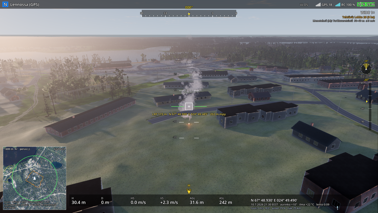
A hiker, hunter, fisher or snowmobiler may have made a campfire beside their rest place (the chance depends on the profile, for example a fisher 40 %, a berry picker 10 %). As long as the person keeps it going, it burns with flames and a column of smoke rises, drifts with the wind and shows from far in the visible camera. In the thermal camera the fire pit is a hot spot. When the person leaves or is too weak to feed it, the flames die down in an hour and a half and the embers cool for hours: the thermal camera sees them long after the smoke is gone. The fire is marked with the laser like found items. The terrain also has old fire rings along paths and shores: a ring of stones without heat, a distractor.
The missing person may move
The person does not always stay put. A child or a person with dementia may wander (a few moves of 80–300 m with rests), a berry picker, hiker or hunter may try to get back to a road or a path, a weakened or lying person stays put. A moving person is upright, leaves a fresh track in the snow and fresh scent for the dogs, and their place changes during the search: the segment where they were may be empty by the time someone gets there.